On Top of the World
or at least Connecticut'
Bear Mountain, Mt. Frissell Brace Mountain
 |
| Bear Mountain - as seen from the west on Mt Frissell |
We started from the Route 41 parking lot and trailhead, about three miles north of Salisbury , CT 9am . Two groups headed up with us, but we were hiking at a pretty good pace, and lost them after a few minutes. The hike starts with a brief walk through the flats, then a steady incline up the west side of Bear Mountain - it's a workout!
We passedParadise lane, a cutoff trail that leads north around the summit of Bear instead of going over the top. Note - This makes a good 6.7 mile loop hike if you just do Bear Mountain – head up over the summit and then take the Paradise Lane Trail
We passed
The trail levels off for a little while, and then starts back up again heading to the Riga Junction on the Appalachian Trail . Connecticut
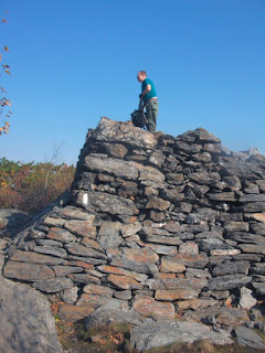
After another steep climb, the trail levels off again as the trees give way to scrub oak and pine nearing the top of the mountain. And then the summit – there’s a stone tower, about eight feet tall, that gets you above the treeline for unrestricted views all around. The tower was originally built in 1885 (much taller with 350 tons of stone hauled up), and since vandalized, fixed, rebuilt and reset. We were about an hour and a quarter into the hike now, so relaxed sitting on the tower enjoying the breeze and views –
Break's over – we headed west off the mountain, bushwacking through what used to the Bee Line trail, hands feet and butts down the rock tracks – wet leaves make slippery rock even more so.
 |
| Hiking into Northwest Camp |
Our hike leader also happened to be the steward for this section of the Frissell Trail. The NHCC has maintained the trail to the tri-state line for about 20 years. So, loppers in hand, we hiked up from the Mt Washington Road Connecticut
Up Round Mountain
After a more gentle descent off Round, it was a tough, steep climb up Mt Frissel. We made the peak from the east side, and then hiked around to the south face of the mountain. I'm not sure what kind of monument to the highest point in Connecticut I expected, but this wasn't it. A rock cairn is built up next to a small green post marking the spot. We broke here for a rest, snack and a little work clearing a view point to the south. If I had phone service up here, I could have texted out how I was head and shoulders above everyone else in the state, but a photo will have to do.
Around the face, then down through birch forest to the tri state marker. This monument, dated 1898, has New York etched on one side, Massachusetts on the other, and a nice blank face pointing into Connecticut. When the marker was placed, Connecticut was still disputing the border. If that dispute is still on, I say we annex Mt Frissell and take the summit as the new highpoint.
 |
| The Frissell Trail just past the New York border |
Continuing west to the end of the Frissell Trail in Taconic State Park, views open up at the southern end of the South Taconic Trail. We made a quick hike up
 |
| The view west from Brace Mountain summit |
I found a video of a flight over the area - check it out here.
The trip back was a quick hike through the open mountain roads - wide level trails that have been used for logging over the years. The trails were swamped in sections – running water down Brace Mountain Bear Mountain road. I got to test that the new boots really are waterproof.
Here's a summary of the hike route:
· Follow the blue blazed Undermountain Trail west from the Rt 41 Trailhead. Pass the Paradise Lane
· Turn north on the white blazed Appalachian Trail to the summit of Bear Mountain (2,326’).
· West off the summit on the Bee Line trail (not well blazed) to the AMC Northwest Camp.
· Continue to Mount Washington Road at the CT-MA state border (marker 198) to the start of the red blazed Frissell Trail.
· Up, over and down Round Mountain
· Up Mt Frissell to the summit. (2,451’)
· Down SSW to the CT Highpoint (2,372’) and green post border marker
· West on Frissell Trail to the tri state marker
· Continue west on Frissell Trail to its end at the South Taconic Trail in Taconic State Park
· White blazed STT south to summit of Brace Mountain
· Backtrack on the STT and then take Brace Mountain Road Mt Washington Rd between Round Mountain Gridley Mountain
· Southwest on Bear Mountain Rd to the AT.
· South on the AT, then east on the Undermountain Trail back to the Rt 41 parking lot.
5 hours out – including time for snacks, lunch, some trail maintenance, rests at the summits and time waiting for me to get my butt up the steep climbs. Just under 2 hours back along the flat mountain roads. Check out the rest of the photos here -


Awesome!
ReplyDeleteSmall world. I was just here recently. Beautiful section in autumn. Glad you enjoyed some fine views.
ReplyDelete