Mattabesett Trail - Reservoir Section
Part 2 - the Mattabesett
Hike date June 13, 2011

I left you right here in Part 1, just off the Reservoir Loop Trail and on the Mattabesett Trail heading north toward River Road. I'll still detail the hike as it's done in the Connecticut Forest and Park Association's Walk Book, but I have to get up to the north trailhead first!
Following the blue blazes is supposed to be easy - just follow the trail and see a blue patch every once in a while to confirm you're in the right place. And it was just like that for a few miles, until I got close to a trail section near power lines. The trail was clear, though there are woods roads and bike/quad trails all through here. The trail obviously bent to the left, and I hiked up and over a ledge crossing, down along a woods road until I realized it's been a long time since I saw a trail blaze! Look forward - no blaze. Look backward - no blaze. Backtrack, follow another clearing, turn around again... if I had a GPS tracking me, the path would look like a very random set of loop-de-loops. No problem, the map showed I should be tracking near the power lines, and I could see the break in treetops where the clearing was, so off I went until I found a few faded blazes and ran smack into a huge blowdown - a big ol' birch tree completely blocking the narrow trail.
I was ready to try and climb through/around the tree, until a four foot black snake slithered across the trail in front of me - and I very quickly decided to bushwhack my way out of there and head to the power line clearing. And after my breathing slowed, and my pulse dropped back to normal, I remembered the black rat snake to be pretty harmless (unless you're a chipmunk, rat, frog...). But that sucker was big... and fast... and, well, slithery!!
The trail crosses the power lines, so I just wandered up and around looking for a clearing or blaze. If you've ever hiked utility corridors and power lines, or better yet tried to maintain a trail there, you know how fast the bushes and vines take over a clearing. Back and forth a little until I found this painted rock and followed the trail down to the end. Don't get me wrong, it's still a great trail here - nothing a chain saw, brush cutter and a little blue paint wouldn't fix!
And now, the Mattabesett Trail and a 5 mile section running south from the River Road trailhead. Since this is an eighty year old trail, one of the original CFPA blue trails and now (with the Metacomet and Menunkatuck Trails) part of the New England Trail, I expected the trailhead to be well marked - maybe a kiosk or signpost or souvenir stand. Nope, you really have to know what you're looking for to find this. Using the Walk Book directions and this power plant as a landmark, you'll find a parking area across the street. The only markings were two little CFPA and NET placards nailed to a tree.


The trail follows the road for a few hundred feet, and then heads into the woods. This section has been reblazed recently, so it's easy to stay on the blue trail as it crosses woods roads and bike trails through the forest. The trail crosses several streams as it heads up the hill to that power line clearing. I walked north a little to get this photo looking down on the Connecticut River.

Follow the trail across the power line clearing, into the woods and southeast parallel to the clearing. It was easier to get around that downed tree from this direction, and I moved sections of it to clear at least half the trail. Continue down across another stream, and into the section where I lost the blazes coming the other way.

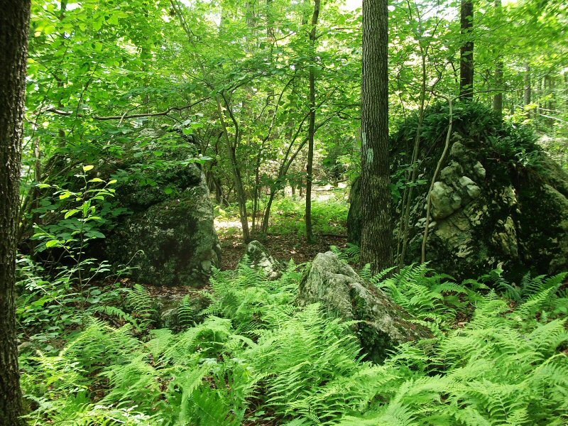
 The trail curves around to bring you through these two large boulders, grey schist and gneiss with chunks of whitish rock (quartz?). Geology on the east leg of the Mattabesett is completely different than the west. On this side, you find these chunky metamorphic rocks and boulders. The west side is characterized by the fine grain basalt - traprock - ridges and cliffs. Find a geologist if you want to learn more - I just notice that the rocks are different!

Watch for blazes along this part of the trail. It follows woods roads, crosses them, and then wanders through the woods and there are so many paths, clearings and trails it's easy to miss a turn. Nearing the two mile mark, the trail turns off one of those woods roads near a marsh and pond - frogs croaking, little water bugs dancing across the pond surface. A log bridge takes you over the inlet stream, and the trail continues on into the woods and groves of mountain laurel.


As I came to another stream crossing, this one over a ladder-type bridge, I met the only other hiker I saw on the trail today - an older gentleman with a big floppy hat, long sleeves rolled up to the elbows, and long pants rolled up to the knees. He had a walking stick in one hand, sandals in the other, and was squishing barefoot through the muddy trail and across the stream. And it looked like he was loving it. He didn't seem in any mood for conversation though, just grinned, nodded and kept on walking.

Continuing past the first Reservoir Road crossing and the north junction with the Blue/Yellow Reservoir Loop, the trail leads a half mile along another woods road at the base of ledges. As you start to hike up hill, the trail comes to a wall of boulders and takes a left up the ledge. This is the Rock Pile cave according to the trail guide - a hollow in the boulders deep enough to be called a cave. A rock wall was built up along the cave opening. I already had my close encounter of the slithering kind for today, so I stayed out of the cave and just hiked up the ledge.
A short walk through the trees and laurel leads out to open rock face and a great view of the reservoir below (this time #1). With the scrub oak and stunted pines trees make a good wind break, I took a break here to enjoy a snack with a view.

The rest was a good idea because the next part of the trail was a workout. There were still streams of water running down the boulders from the recent rain. Scrambling across and down the face of the boulders, I nearly slipped and skidded down into the brush. The trail leads along the ridge and then steeply down to cross another stream. I didn't bring poles today, so was hanging on to bush and tree limbs as I tried to get better footing down the ledge. In dryer weather, this would have been too bad. But wet rock makes the descent really interesting!
After crossing Reservoir Road again and passing another intersection with the loop trail, the rest of the trail leads up and down smaller hills and ledges around the west side of the reservoir. This side has better views to the water than the Loop Trail side, but that side doesn't have the up and down of the rocks and ledges - choose your poison. Nearing the south end of the reservoir, I scared that heron off it's nest again - though still didn't get a picture. But here's one last shot as I went by - off into the woods to that Bear Hill Road parking lot, and my car.

I almost had enough for the day, but remembered there was a new trail nearby that ran along the Connecticut River. Now if I can just find that one...
Hike date June 13, 2011

I left you right here in Part 1, just off the Reservoir Loop Trail and on the Mattabesett Trail heading north toward River Road. I'll still detail the hike as it's done in the Connecticut Forest and Park Association's Walk Book, but I have to get up to the north trailhead first!
Following the blue blazes is supposed to be easy - just follow the trail and see a blue patch every once in a while to confirm you're in the right place. And it was just like that for a few miles, until I got close to a trail section near power lines. The trail was clear, though there are woods roads and bike/quad trails all through here. The trail obviously bent to the left, and I hiked up and over a ledge crossing, down along a woods road until I realized it's been a long time since I saw a trail blaze! Look forward - no blaze. Look backward - no blaze. Backtrack, follow another clearing, turn around again... if I had a GPS tracking me, the path would look like a very random set of loop-de-loops. No problem, the map showed I should be tracking near the power lines, and I could see the break in treetops where the clearing was, so off I went until I found a few faded blazes and ran smack into a huge blowdown - a big ol' birch tree completely blocking the narrow trail.
I was ready to try and climb through/around the tree, until a four foot black snake slithered across the trail in front of me - and I very quickly decided to bushwhack my way out of there and head to the power line clearing. And after my breathing slowed, and my pulse dropped back to normal, I remembered the black rat snake to be pretty harmless (unless you're a chipmunk, rat, frog...). But that sucker was big... and fast... and, well, slithery!!
 |
| There's the blaze, but do you see a trail? |
And now, the Mattabesett Trail and a 5 mile section running south from the River Road trailhead. Since this is an eighty year old trail, one of the original CFPA blue trails and now (with the Metacomet and Menunkatuck Trails) part of the New England Trail, I expected the trailhead to be well marked - maybe a kiosk or signpost or souvenir stand. Nope, you really have to know what you're looking for to find this. Using the Walk Book directions and this power plant as a landmark, you'll find a parking area across the street. The only markings were two little CFPA and NET placards nailed to a tree.


The trail follows the road for a few hundred feet, and then heads into the woods. This section has been reblazed recently, so it's easy to stay on the blue trail as it crosses woods roads and bike trails through the forest. The trail crosses several streams as it heads up the hill to that power line clearing. I walked north a little to get this photo looking down on the Connecticut River.

Follow the trail across the power line clearing, into the woods and southeast parallel to the clearing. It was easier to get around that downed tree from this direction, and I moved sections of it to clear at least half the trail. Continue down across another stream, and into the section where I lost the blazes coming the other way.

 The trail curves around to bring you through these two large boulders, grey schist and gneiss with chunks of whitish rock (quartz?). Geology on the east leg of the Mattabesett is completely different than the west. On this side, you find these chunky metamorphic rocks and boulders. The west side is characterized by the fine grain basalt - traprock - ridges and cliffs. Find a geologist if you want to learn more - I just notice that the rocks are different!
Watch for blazes along this part of the trail. It follows woods roads, crosses them, and then wanders through the woods and there are so many paths, clearings and trails it's easy to miss a turn. Nearing the two mile mark, the trail turns off one of those woods roads near a marsh and pond - frogs croaking, little water bugs dancing across the pond surface. A log bridge takes you over the inlet stream, and the trail continues on into the woods and groves of mountain laurel.


As I came to another stream crossing, this one over a ladder-type bridge, I met the only other hiker I saw on the trail today - an older gentleman with a big floppy hat, long sleeves rolled up to the elbows, and long pants rolled up to the knees. He had a walking stick in one hand, sandals in the other, and was squishing barefoot through the muddy trail and across the stream. And it looked like he was loving it. He didn't seem in any mood for conversation though, just grinned, nodded and kept on walking.

Continuing past the first Reservoir Road crossing and the north junction with the Blue/Yellow Reservoir Loop, the trail leads a half mile along another woods road at the base of ledges. As you start to hike up hill, the trail comes to a wall of boulders and takes a left up the ledge. This is the Rock Pile cave according to the trail guide - a hollow in the boulders deep enough to be called a cave. A rock wall was built up along the cave opening. I already had my close encounter of the slithering kind for today, so I stayed out of the cave and just hiked up the ledge.
 |
| Boulders and ledge at "Rock Pile Cave" |
 |
| Peering into the cave - plenty of room |
 |
| The trail climbs up and around the ledge. |
 |
| Asylum Reservoir #1 |

The rest was a good idea because the next part of the trail was a workout. There were still streams of water running down the boulders from the recent rain. Scrambling across and down the face of the boulders, I nearly slipped and skidded down into the brush. The trail leads along the ridge and then steeply down to cross another stream. I didn't bring poles today, so was hanging on to bush and tree limbs as I tried to get better footing down the ledge. In dryer weather, this would have been too bad. But wet rock makes the descent really interesting!
After crossing Reservoir Road again and passing another intersection with the loop trail, the rest of the trail leads up and down smaller hills and ledges around the west side of the reservoir. This side has better views to the water than the Loop Trail side, but that side doesn't have the up and down of the rocks and ledges - choose your poison. Nearing the south end of the reservoir, I scared that heron off it's nest again - though still didn't get a picture. But here's one last shot as I went by - off into the woods to that Bear Hill Road parking lot, and my car.

I almost had enough for the day, but remembered there was a new trail nearby that ran along the Connecticut River. Now if I can just find that one...


Hey Jim, nice work catching the photo of the frog! I can't say I've seen a frog in the wild down here. I hear them, but never see them :)
ReplyDeleteHalf a second earlier, he was on a log. All framed up and he jumped - but I got this off before he dove for the weeds. They're camera shy I guess.
ReplyDelete