Good Things, Small Packages - Southford Falls State Park

There are over a hundred state parks in little
But I am a sucker for waterfalls, and when a
photo group planned a shoot at Southford Falls

The falls run on Eight Mile Brook as it flows
from Lake Quassapaug Housatonic River
 |
| Eight Mile Brook as it rushes down from the falls under the Covered Bridge |
The steep drop of the river, coupled with the narrow
channel through the rock ledge, made this a good spot for water power in the
1800’s. Fabric mills, saw mills and
grist mills were built along the banks. In 1855, a papermill was built on the
falls. A second mill was built a little
farther south, and a raceway from the falls brought steady supply of water
there. Over time, the paper mill was
expanded, and a dam was built for power generation – creating what is now
Papermill Pond on the north side of the park.
The Diamond Match Company bought the mill, and operated it producing
cardboard until it burned around 19251.
 |
| The Diamond Match Company papermill, with the falls at the right side of the page. from History of the Town of Oxford, Connecticut, Litchfield and Hoyt, 1960 |
Looking around now, with the park and river
and bridle trail, you might describe the area as peaceful, bucolic, serene,
pastoral… But in the early 1900’s the
river was heavily polluted, and the noise from the mills must have been
deafening. After the mill burned, the
property was sold and eventually given to the state. Finally, in the 1930’s, workers with the
Civilian Conservation Corps removed remains of the mill buildings and cleared
the way for the state park as it sits now.
I include that history lesson because (one) I
just like history and know our state parks didn’t just appear out of thin air one
day, and (two) you can explore around the falls and find remnants of
foundations and the raceway, so now you know what the heck they are. You can get even more detail at the Oxford Historical Society or the town's Municipal History page.
The nearly two-mile long loop trail goes past
the falls, across a covered bridge, along the river through a pine forest and
over a short boardwalk on the river bank.
And that’s just the first third of a mile.
 |
| Picturesque covered bridge. It's good they put that sign up, otherwise we wouldn't know what that red thing was! |
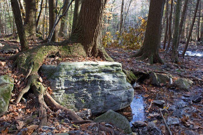 |
| Tree latched onto a boulder. Check the rock formations as you pass through the ledge channel. Rockhounds - look for Collinsville Formation in the outcrop uphill from here |
 |
| Boardwalk along the river bank |
The trail continues around through the hardwood forest over ledge and marsh, with a spur that heads up to an observation tower. The trees have grown up as tall as the tower, so the view is only open toward the west. But it's fun to climb and have a look anyway.

 |
| Reflecting pool above the falls |
If two miles isn’t enough of a hike for you, go around again and see what you missed the first time. Past the wetlands, the trail leads along the bank of Papermill Pond, a stocked and protected trout park. Next to the pond, there is a large picnic area and pavilion, and a big open grassy area.

1 Norman Litchfield and Sabina Connolly Hoyt PhD, History of the Town of Oxford, Connecticut,
Oxford, CT 1960.


Great report on the park. your pictures are fantastic. I will put this place on my list for the spring so i can hike it and then fish the trout park. 70 bucks to get your deer butchered is actually one heck of a deal.
ReplyDeleteGreatly enjoyed your post. Unless you object, I've shared it on my state parks web magazine, http://www.scoop.it/t/state-parks/
ReplyDeleteImagine that - a match company burning down?!! Looks like a great hike! Great pictures, too - how would this be for one of our winter hikes?
ReplyDeletegreat shots and documentary,Jim, Thanks for posting!! :p)
ReplyDeleteGreat post. I grew up in Connecticut and this post is making me homesick! Thanks.
ReplyDeleteDani @ ONNO Hemp Clothing
i like your blogger nice blogger
ReplyDeleteThanks Kash
DeleteI love the pictures. Makes me want to come out and visit you from Colorado! I particularly love the covered bridge photo.
ReplyDeleteThanks for sharing.
Well, now that I'm in Colorado, I might have to swing over and see you! Thanks for stopping by.
DeleteGreat blog...don't stop! Would love to see more on your adventures from this summer. :)
ReplyDeleteAwesome park report, Nice pictures.
ReplyDeleteSpring is almost here so Will be Hiking there, go fishing in the trout park.
Always enhances the adventure when history and the historical structures are included. Great right up. www.islikely.com for the weather, cool site.
ReplyDelete